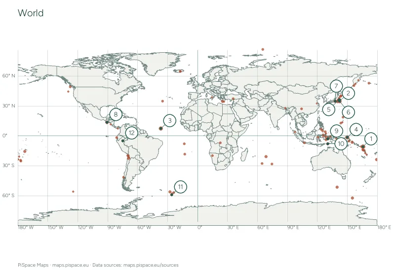
Past-week earthquakes map and plotting activity
A dated USGS magnitude 4.5+ earthquake map, a coordinate plotting worksheet and the full snapshot event table.
- Difficulty
- Advanced
- PDF pages
- 8
- Places or points
- 12
Download this resource
Choose the paper size and version that work for your lesson.
A4 · Colour8-page PDF with source credits and the reference material shown on this page.A4 · Ink-saving8-page PDF with source credits and the reference material shown on this page.US Letter · Colour8-page PDF with source credits and the reference material shown on this page.US Letter · Ink-saving8-page PDF with source credits and the reference material shown on this page.
For printing, select the paper size shown on your download. Check the print preview before making classroom copies. Printing guide
Using this activity
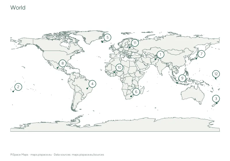
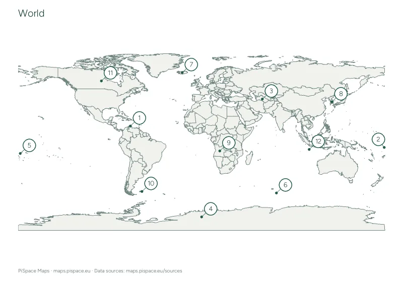
- The map plots all valid earthquake events in this dated USGS magnitude 4.5+ seven-day snapshot.
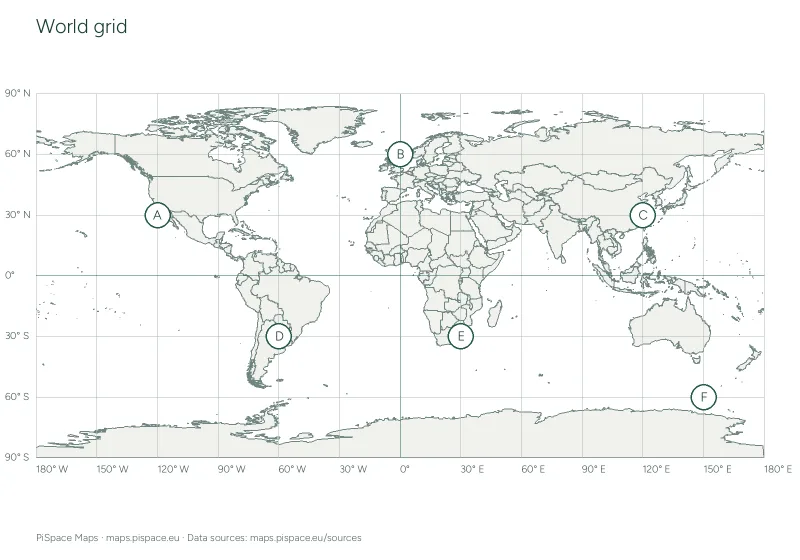
- The twelve numbered events are selected by highest reported magnitude for the plotting exercise. Enter latitude and longitude in the worksheet.
- Use the dated event table to check magnitude, depth and UTC time. Source events can be revised; this is a daily snapshot, not a live alert or forecast.
What to practise
- Interpret an event map and compare magnitudes.
- Plot geographic coordinates from a dated scientific source.
Reference data
| Event location | Magnitude and depth | Event time |
|---|---|---|
| 30 km WSW of Lata, Solomon Islands | M 6.4 · 17 km | 2026-11-09 03:34 UTC |
| central Mid-Atlantic Ridge | M 5.8 · 10 km | 2026-11-07 23:17 UTC |
| 148 km NW of Kavieng, Papua New Guinea | M 5.8 · 10 km | 2026-11-12 22:04 UTC |
| 79 km WSW of Changuillo, Peru | M 5.8 · 10 km | 2026-11-13 16:43 UTC |
| 106 km ENE of Hasaki, Japan | M 5.7 · 24.173 km | 2026-11-09 04:52 UTC |
| 74 km NE of Hasaki, Japan | M 5.5 · 31.748 km | 2026-11-07 11:07 UTC |
| 8 km E of Shinshiro, Japan | M 5.5 · 37.07 km | 2026-11-07 16:04 UTC |
| 40 km S of Puerto San José, Guatemala | M 5.5 · 59.652 km | 2026-11-10 14:54 UTC |
| 160 km E of Masohi, Indonesia | M 5.4 · 10 km | 2026-11-09 09:48 UTC |
| Pulau Pulau Tanimbar, Indonesia | M 5.4 · 10 km | 2026-11-10 01:53 UTC |
| South Sandwich Islands region | M 5.4 · 121.557 km | 2026-11-12 03:45 UTC |
| 80 km ENE of Lagunas, Peru | M 5.3 · 11.49 km | 2026-11-09 10:23 UTC |
| 19 km WSW of Lata, Solomon Islands | M 5.2 · 10 km | 2026-11-10 03:37 UTC |
| 21 km WNW of Popondetta, Papua New Guinea | M 5.2 · 124.245 km | 2026-11-10 17:36 UTC |
| Mid-Indian Ridge | M 5.2 · 10 km | 2026-11-10 17:36 UTC |
| West Chile Rise | M 5.2 · 10 km | 2026-11-13 14:12 UTC |
| 79 km NE of Kuqa, China | M 5.2 · 10 km | 2026-11-13 16:17 UTC |
| off the west coast of northern Sumatra | M 5.2 · 10 km | 2026-11-14 02:59 UTC |
| 91 km ENE of Hihifo, Tonga | M 5.1 · 10 km | 2026-11-07 23:27 UTC |
| south of the Fiji Islands | M 5.1 · 535.494 km | 2026-11-09 00:46 UTC |
| 139 km ESE of Labuha, Indonesia | M 5.1 · 10 km | 2026-11-10 15:51 UTC |
| Balleny Islands region | M 5.1 · 10 km | 2026-11-11 06:21 UTC |
| Pulau Pulau Tanimbar, Indonesia | M 5.1 · 14.704 km | 2026-11-11 11:32 UTC |
| 27 km WSW of Calama, Chile | M 5.1 · 91.309 km | 2026-11-11 11:36 UTC |
| South Sandwich Islands region | M 5.1 · 104.66 km | 2026-11-11 15:39 UTC |
| 81 km W of Panguna, Papua New Guinea | M 5.1 · 74.384 km | 2026-11-11 17:38 UTC |
| western Indian-Antarctic Ridge | M 5.1 · 10 km | 2026-11-12 21:09 UTC |
| 39 km S of Moíres, Greece | M 5.1 · 43.358 km | 2026-11-13 00:05 UTC |
| South Sandwich Islands region | M 5.1 · 63.81 km | 2026-11-13 19:04 UTC |
| 153 km NW of Kavieng, Papua New Guinea | M 5.1 · 10 km | 2026-11-13 23:30 UTC |
| 58 km NE of Fef, Indonesia | M 5.0 · 35 km | 2026-11-10 08:34 UTC |
| 152 km SE of Kuril’sk, Russia | M 5.0 · 30.338 km | 2026-11-11 05:26 UTC |
| 85 km W of Mwene-Ditu, Democratic Republic of the Congo | M 5.0 · 10 km | 2026-11-13 01:12 UTC |
| southern Mid-Atlantic Ridge | M 4.9 · 10 km | 2026-11-07 11:35 UTC |
| 73 km NNW of Khorixas, Namibia | M 4.9 · 10 km | 2026-11-07 15:22 UTC |
| 41 km WSW of Gadung, Philippines | M 4.9 · 607.007 km | 2026-11-07 23:25 UTC |
| south of the Fiji Islands | M 4.9 · 136.311 km | 2026-11-09 02:21 UTC |
| Mid-Indian Ridge | M 4.9 · 10 km | 2026-11-09 15:04 UTC |
| south of the Fiji Islands | M 4.9 · 175.527 km | 2026-11-09 23:45 UTC |
| north of Franz Josef Land | M 4.9 · 10 km | 2026-11-10 02:00 UTC |
| 78 km ESE of Hitachi, Japan | M 4.9 · 35 km | 2026-11-10 05:20 UTC |
| South Sandwich Islands region | M 4.9 · 10 km | 2026-11-09 23:40 UTC |
| 207 km NW of Port-Olry, Vanuatu | M 4.9 · 11.705 km | 2026-11-10 19:54 UTC |
| 48 km NW of Ancud, Chile | M 4.9 · 18.804 km | 2026-11-11 19:21 UTC |
| 116 km E of Georgetown, Saint Helena | M 4.9 · 10 km | 2026-11-11 22:03 UTC |
| 41 km N of Weining, China | M 4.9 · 10 km | 2026-11-12 20:03 UTC |
| Pagan region, Northern Mariana Islands | M 4.9 · 219.572 km | 2026-11-13 02:55 UTC |
| southeast of the Loyalty Islands | M 4.9 · 10 km | 2026-11-13 09:55 UTC |
| south of the Fiji Islands | M 4.9 · 563.277 km | 2026-11-13 18:55 UTC |
| south of the Kermadec Islands | M 4.9 · 36.931 km | 2026-11-13 22:10 UTC |
| central Mid-Atlantic Ridge | M 4.8 · 10 km | 2026-11-08 16:33 UTC |
| 26 km SW of Lata, Solomon Islands | M 4.8 · 10 km | 2026-11-09 05:16 UTC |
| 183 km E of Masohi, Indonesia | M 4.8 · 10 km | 2026-11-09 09:53 UTC |
| 149 km NW of Port-Olry, Vanuatu | M 4.8 · 10 km | 2026-11-09 19:27 UTC |
| northern Mid-Atlantic Ridge | M 4.8 · 10 km | 2026-11-10 06:43 UTC |
| 33 km S of Puerto San José, Guatemala | M 4.8 · 58.303 km | 2026-11-10 15:23 UTC |
| 20 km SSW of Lata, Solomon Islands | M 4.8 · 48.333 km | 2026-11-10 15:52 UTC |
| 43 km SE of Severo-Kuril’sk, Russia | M 4.8 · 74.47 km | 2026-11-12 01:18 UTC |
| 155 km E of Noda, Japan | M 4.8 · 33.039 km | 2026-11-12 04:07 UTC |
| 59 km WSW of Houma, Tonga | M 4.8 · 162.78 km | 2026-11-13 11:18 UTC |
| 10 km SW of Guaymate, Dominican Republic | M 4.8 · 136.742 km | 2026-11-13 16:35 UTC |
| 153 km NW of Kavieng, Papua New Guinea | M 4.8 · 10 km | 2026-11-13 19:49 UTC |
| 156 km ESE of Modisi, Indonesia | M 4.7 · 38.531 km | 2026-11-07 09:47 UTC |
| 45 km NNW of Salinas, Ecuador | M 4.7 · 10 km | 2026-11-07 17:17 UTC |
| 43 km ESE of Ambon, Indonesia | M 4.7 · 136.656 km | 2026-11-07 20:55 UTC |
| 137 km E of Miyako, Japan | M 4.7 · 10 km | 2026-11-08 09:23 UTC |
| 46 km NW of Huara, Chile | M 4.7 · 68.785 km | 2026-11-08 11:58 UTC |
| Southwest Indian Ridge | M 4.7 · 10 km | 2026-11-08 12:29 UTC |
| 119 km SW of Kokopo, Papua New Guinea | M 4.7 · 120.843 km | 2026-11-08 22:30 UTC |
| 271 km N of Tobelo, Indonesia | M 4.7 · 98.292 km | 2026-11-09 11:25 UTC |
| 17 km NW of İmamoğlu, Turkey | M 4.7 · 10 km | 2026-11-09 12:28 UTC |
| 103 km W of Attu Station, Alaska | M 4.7 · 10 km | 2026-11-09 22:03 UTC |
| 90 km SSE of Tateyama, Japan | M 4.7 · 10 km | 2026-11-10 06:36 UTC |
| 111 km WNW of Höfn, Iceland | M 4.7 · 10 km | 2026-11-10 13:37 UTC |
| Java, Indonesia | M 4.7 · 101.214 km | 2026-11-10 14:31 UTC |
| 130 km W of Tofino, Canada | M 4.7 · 10 km | 2026-11-11 01:45 UTC |
| 152 km WSW of Merizo Village, Guam | M 4.7 · 137.374 km | 2026-11-11 08:37 UTC |
| 168 km W of Fakfak, Indonesia | M 4.7 · 10 km | 2026-11-11 12:17 UTC |
| 83 km NE of Ruteng, Indonesia | M 4.7 · 10 km | 2026-11-12 11:16 UTC |
| 27 km NNE of Labuan Lombok, Indonesia | M 4.7 · 9.626 km | 2026-11-13 04:49 UTC |
| 54 km NW of San Antonio de los Cobres, Argentina | M 4.7 · 216.092 km | 2026-11-14 03:18 UTC |
| South Sandwich Islands region | M 4.6 · 103.682 km | 2026-11-07 07:14 UTC |
| 117 km NE of Tobelo, Indonesia | M 4.6 · 224.59 km | 2026-11-08 16:45 UTC |
| 69 km ESE of Takahagi, Japan | M 4.6 · 35 km | 2026-11-09 05:01 UTC |
| 54 km S of Klyuchi, Russia | M 4.6 · 154.988 km | 2026-11-09 07:04 UTC |
| 206 km E of Kirakira, Solomon Islands | M 4.6 · 10 km | 2026-11-09 18:51 UTC |
| south of the Fiji Islands | M 4.6 · 519.944 km | 2026-11-09 19:09 UTC |
| 65 km SW of Lata, Solomon Islands | M 4.6 · 10 km | 2026-11-10 04:30 UTC |
| 130 km ENE of Hasaki, Japan | M 4.6 · 10 km | 2026-11-11 03:56 UTC |
| 54 km WNW of Malfa, Italy | M 4.6 · 10 km | 2026-11-11 05:12 UTC |
| 64 km NW of Port-Vila, Vanuatu | M 4.6 · 42.696 km | 2026-11-11 10:57 UTC |
| 130 km E of Masohi, Indonesia | M 4.6 · 10 km | 2026-11-11 12:10 UTC |
| 73 km NNW of Gyalshing, India | M 4.6 · 10 km | 2026-11-11 23:00 UTC |
| 117 km S of Akureyri, Iceland | M 4.6 · 10 km | 2026-11-12 21:53 UTC |
| 18 km WNW of Río Grande, Panama | M 4.6 · 10 km | 2026-11-13 08:01 UTC |
| 84 km E of Barcelona, Philippines | M 4.6 · 10 km | 2026-11-13 09:40 UTC |
| 33 km SSW of La Libertad, El Salvador | M 4.6 · 59.125 km | 2026-11-13 21:19 UTC |
| 74 km S of Yudomari, Japan | M 4.6 · 40.852 km | 2026-11-13 23:22 UTC |
| 100 km WSW of Lebu, Chile | M 4.6 · 10 km | 2026-11-13 23:55 UTC |
| 57 km SW of Ollagüe, Chile | M 4.5 · 110.716 km | 2026-11-07 10:53 UTC |
| Fiji region | M 4.5 · 571.898 km | 2026-11-07 15:05 UTC |
| 11 km ESE of Pedasí, Panama | M 4.5 · 10 km | 2026-11-07 16:01 UTC |
| 65 km WSW of Masachapa, Nicaragua | M 4.5 · 37.054 km | 2026-11-07 19:55 UTC |
| 77 km SW of La Gomera, Guatemala | M 4.5 · 34.237 km | 2026-11-07 23:22 UTC |
| 11 km W of Honmachi, Japan | M 4.5 · 10 km | 2026-11-08 01:53 UTC |
| central Mid-Atlantic Ridge | M 4.5 · 10 km | 2026-11-07 07:46 UTC |
| 43 km E of Onagawa Chō, Japan | M 4.5 · 55.699 km | 2026-11-08 20:16 UTC |
| 152 km E of Masohi, Indonesia | M 4.5 · 10 km | 2026-11-09 16:52 UTC |
| 224 km W of Abepura, Indonesia | M 4.5 · 35 km | 2026-11-10 00:11 UTC |
| 61 km ENE of Blangpidie, Indonesia | M 4.5 · 10 km | 2026-11-10 22:09 UTC |
| 16 km SSE of Gaoyou, China | M 4.5 · 10 km | 2026-11-10 22:15 UTC |
| 62 km NNE of Port-Olry, Vanuatu | M 4.5 · 149.444 km | 2026-11-11 12:45 UTC |
| south of the Fiji Islands | M 4.5 · 527.582 km | 2026-11-11 19:50 UTC |
| 41 km SSE of Camiña, Chile | M 4.5 · 112.957 km | 2026-11-11 20:45 UTC |
| off the coast of Oregon | M 4.5 · 10 km | 2026-11-12 08:17 UTC |
| 3 km E of Tako, Japan | M 4.5 · 73.353 km | 2026-11-12 13:27 UTC |
| 115 km ESE of Bitung, Indonesia | M 4.5 · 39.203 km | 2026-11-12 14:58 UTC |
| 278 km E of Levuka, Fiji | M 4.5 · 527.134 km | 2026-11-13 02:26 UTC |
| 86 km NNE of Lagunas, Peru | M 4.5 · 10 km | 2026-11-13 10:55 UTC |
| 9 km WSW of Chaparral, Colombia | M 4.5 · 10 km | 2026-11-13 19:43 UTC |
| Fiji region | M 4.5 · 587.447 km | 2026-11-14 02:21 UTC |
Map data: USGS and Natural Earth. Snapshot retrieved 2026-11-14 03:35:02 UTC. Seven-day feed snapshot generated 2026-11-14 03:35 UTC. Boundaries are simplified for printing. Sources and licences